Professional Development to Improve the Spatial Thinking of Earth Science Teachers and Their Students
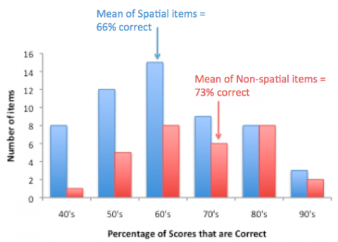
Spatial thinking involves drawing meaning from the position, shape, orientation, trajectory, or configuration of objects or phenomena. For any kind of data displayed on a map or cross-section, spatial thinking is likely to be an important cognitive tool. In this project, we analyzed over 1,000 items from the end-of-course earth science exam given to students in New York state to determine what kinds of spatial thinking were required. We found out that spatial thinking is very common, occurring in 53% of items, and that spatial items are harder on average than non-spatial items. We also developed a professional development workshop series to help earth science teachers understand and foster spatial thinking. This project is a collaboration with teacher Michael J. Passow of Lamont-Doherty Earth Observatory and Dwight Morrow High School, and was funded by NSF grant GEO10-34994 to Columbia University.

